
Caspian Sea’s Shrinking
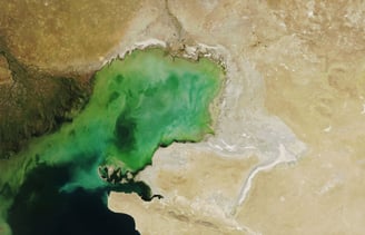
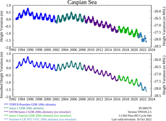
Our satellite monitoring reveals dramatic changes in the Caspian Sea over three decades (1993-2024). Analysis of optical satellite imagery has documented a significant seawater withdrawal affecting 500 square kilometers of Azerbaijan's coastline.

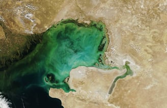

NASA, September 20, 2006
NASA, September 19, 2022
Innovative Environmental Solutions
Leveraging satellite imagery and AI to protect the Caspian Sea and promote sustainable practices.
Advanced AI Models
Utilizing AI/ML to identify threats like pollution and water scarcity in the Caspian Sea region.
Collaborative Research Efforts
Integrating global data sources to support sustainable fisheries, tourism, and social stability in Azerbaijan.
Implementing strategies aligned with the Tehran Convention for effective environmental protection and international cooperation.
Proactive Environmental Monitoring


Caspian Protection
Innovative research for sustainable Caspian Sea management and protection.
Environmental Monitoring
We would like to employ state-of-the-art tools for comprehensive environmental monitoring of the Caspian Sea. This includes ground sensors that track humidity, temperature, and other critical environmental parameters in real time.
In addition, we use Geographic Information Systems (GIS) to map and analyze spatial data, providing insights into land use changes, shoreline erosion, and environmental impacts. GIS tools enable us to visualize complex environmental trends and identify regions in need of conservation efforts. Satellite imagery, combined with sensor data, allows us to monitor changes in the sea's surface area and track the movement of pollutants or invasive species.


AI Solutions


Artificial Intelligence (AI) and Machine Learning (ML) play a crucial role in enhancing our ability to predict and manage the Caspian Sea's environmental challenges. Through AI algorithms, we analyze large datasets generated by environmental sensors, satellite imagery, and historical records to detect patterns and predict future trends. ML models help us identify emerging risks, such as shifts in biodiversity, pollution hotspots, and potential threats to local ecosystems.
These technologies enable rapid analysis and decision-making, providing real-time insights into critical issues like water quality and species population trends. By applying AI and ML to the monitoring data, we can offer data-driven recommendations for policy-making and effective intervention strategies. Our use of predictive modeling also helps anticipate the effects of climate change, human activity, and other factors, empowering stakeholders with the information needed to take timely and effective action in protecting the Caspian Sea.
By integrating advanced monitoring systems and AI/ML technologies, we aim to create a more sustainable, resilient, and well-managed Caspian Sea, ensuring its protection for generations to come.
References & Resources
Azercosmos - the Space Agency of the Republic of Azerbaijan's Climate Report (https://climatereport.az/)
Britannica - Caspian Sea (Accessed October 7, 2022)
Koriche, S.A. et al. (2021) - The Fate of the Caspian Sea under Projected Climate Change and Water Extraction During the 21st Century
Environmental Research Letters 16, 094024Mitrofanov, I.V. and Mamilov, N.Sh. (2015) - Fish Diversity and Fisheries in the Caspian Sea and Aral–Syr Darya Basin in the Republic of Kazakhstan at the Beginning of the 21st Century
Aquatic Ecosystem Health & Management 18 (2), 160–170MODIS Image of the Day (2022, September 15) - The Shrinking Coastline of the Caspian Sea (Accessed October 7, 2022)
NASA Earth Observatory (2021, November 6) - The Caspian’s Shallow North
Natural History (2011–2012) - Fate of the Caspian Sea (Accessed October 7, 2022)
SeafoodSource (2021, February 12) - After Long Commercial Fishing Shutdown, Anchovy Showing Up in Abundance in Caspian Sea (Accessed October 7, 2022)
Worldview (2014, May 19) - The Strategic Importance of the Caspian Sea (Accessed October 7, 2022)
Protecting the Caspian Sea through advanced technology.
© 2025. All rights reserved.
Contact: